Geographic Information Systems (GIS) have become essential tools across various industries, providing a better understanding of geographical data through maps and spatial analysis. From urban planning and agriculture to environmental monitoring and logistics, GIS solutions are widely used to collect, analyze, and visualize geographical information. This technology helps organizations make informed decisions, plan efficiently, and optimize resources. GIS solution providers play a crucial role in making this technology accessible to businesses, governments, and researchers. These providers offer software, hardware, and services that enable organizations to capture, store, and analyze geographic data. In this article, we explore some of the top GIS solution providers and how they are transforming industries with their innovative products and services.
1. Esri: A Global Leader in GIS Solutions
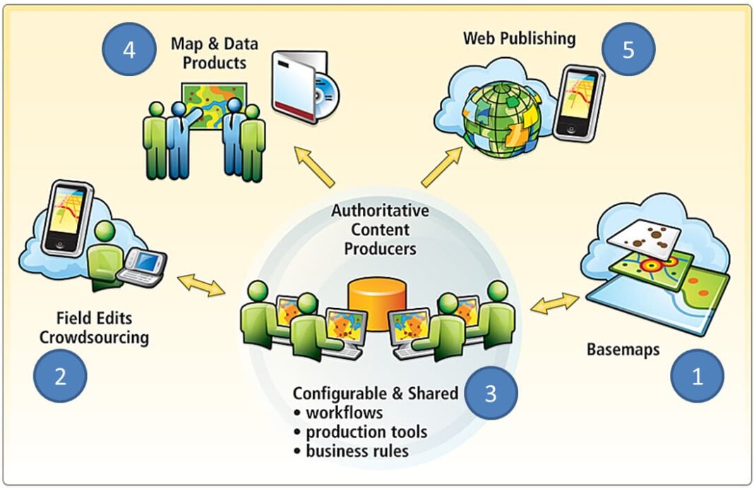
Environmental Systems Research Institute (Esri) is one of the most well-known GIS solution providers in the world. Founded in 1969, Esri is a pioneer in the development of GIS software and services. Its flagship product, ArcGIS, is used by millions of professionals worldwide for mapping, spatial analysis, and data management. ArcGIS offers a comprehensive platform for various industries, including agriculture, transportation, urban planning, and disaster management. Users can create interactive maps, analyze spatial data, and generate reports to help them make better decisions. Esri also offers cloud-based solutions, mobile applications, and open-source tools to ensure that GIS technology is accessible to all types of users. Esri’s ArcGIS Online platform allows users to share and collaborate on spatial data in real-time, making it an essential tool for organizations with distributed teams. The company also provides extensive training and support to help users get the most out of their GIS software.
2. Hexagon: Advanced Geospatial Technologies
Hexagon is another global leader in GIS solutions, providing innovative technologies for industries like defense, aerospace, agriculture, and transportation. Hexagon’s Geospatial division offers a wide range of software tools that allow users to capture, process, and visualize geographic data. Hexagon’s flagship product, M.App Enterprise, is a powerful platform that allows users to create custom GIS applications for their specific needs. With M.App Enterprise, organizations can build web-based and mobile apps that incorporate geospatial data, real-time monitoring, and advanced analytics. This flexibility makes it a popular choice for industries that require tailored GIS solutions. In addition to its software products, Hexagon offers hardware solutions such as high-precision GPS devices, drones, and satellite imagery, providing end-to-end GIS solutions for various industries. Hexagon’s focus on innovation ensures that its clients can access the latest advancements in geospatial technology.

3. Trimble: Geospatial Solutions for Precision and Efficiency
Trimble is a global company known for its geospatial solutions that enhance precision and efficiency across various sectors, including agriculture, construction, transportation, and environmental monitoring. Trimble’s GIS solutions integrate hardware, software, and services to help organizations manage geographic data in real time. One of Trimble’s popular GIS products is the Trimble Catalyst, a GPS-enabled solution that turns mobile devices into high-accuracy data collection tools. This solution is ideal for fieldwork in industries like agriculture, forestry, and environmental conservation. With Trimble Catalyst, users can collect and analyze geographic data directly from their smartphones or tablets, making GIS more accessible and efficient. Trimble also offers cloud-based GIS solutions like TerraFlex, which allows users to collect, share, and analyze spatial data in real time. These solutions are designed to streamline data collection, improve decision-making, and enhance collaboration across teams.
4. Google Maps Platform: Simple Yet Powerful GIS Capabilities
Google Maps Platform is a popular choice for organizations looking for simple yet powerful GIS capabilities. While not a traditional GIS provider, Google Maps offers a range of geospatial tools and APIs that allow businesses to incorporate location-based data into their applications. Google Maps Platform provides services like geocoding, routing, and real-time traffic updates, making it a valuable tool for industries like logistics, transportation, and retail. Companies can use Google’s APIs to build custom mapping applications, track vehicles in real time, and optimize delivery routes. Google’s cloud-based infrastructure ensures that its GIS services are scalable and reliable, making it a go-to solution for businesses of all sizes. While it may not offer the same advanced features as traditional GIS software, Google Maps Platform is widely used for its simplicity, ease of use, and accessibility.
5. Autodesk: Integrating GIS with Design
Autodesk is known for its design software, but it also offers powerful GIS solutions that integrate geographic data with design tools. Autodesk’s GIS products are widely used in industries like architecture, engineering, and construction, allowing users to create detailed models that incorporate spatial data. Autodesk’s Civil 3D is a popular product that combines GIS and design capabilities, helping engineers and architects create accurate models of infrastructure projects. Users can integrate data from various sources, such as satellite imagery and surveys, to build detailed maps and designs. By integrating GIS with design software, Autodesk helps organizations improve accuracy, reduce errors, and optimize their projects. This combination of GIS and design is particularly valuable for large-scale construction and infrastructure projects that require precise planning and execution. GIS solution providers are transforming industries by making geographic data more accessible, accurate, and actionable. From advanced software platforms to GPS-enabled hardware, these companies offer a wide range of tools that help organizations make better decisions, improve efficiency, and optimize resources.
Esri, Hexagon, Trimble, Google Maps Platform, and Autodesk are just a few of the leading GIS solution providers driving innovation in the field of geospatial technology. As industries continue to rely on geographic data for decision-making, these companies will play an increasingly important role in shaping the future of GIS and its applications. By making GIS technology accessible to businesses, governments, and researchers, these solution providers are paving the way for smarter, more efficient decision-making across the globe.


